What is the history of South Melbourne?
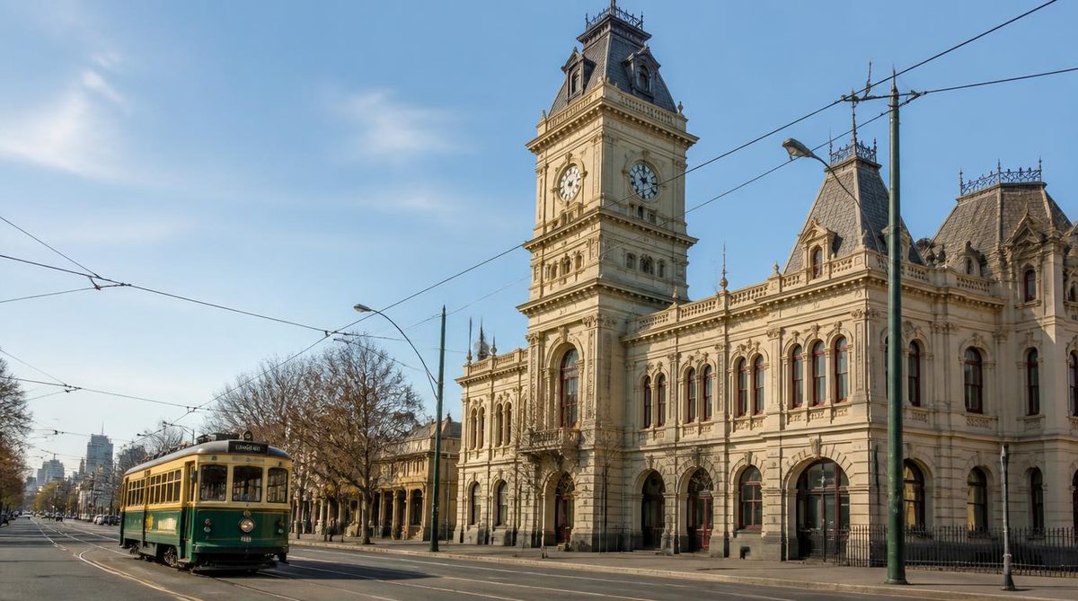
South Melbourne grew from an elevated settlement called Emerald Hill into a dense town with its own council, market, railway, industries and civic centre. Its name changed to South Melbourne in 1883. The municipality remained independent until 1994, when it became part of the City of Port Phillip.
This history is still easy to read on the ground. The rise around the former town hall marks Emerald Hill. The market marks the old commercial centre. Compact Victorian homes show where the population gathered, while flatter land toward Montague holds traces of factories, warehouses and transport routes.
Yet the story did not begin with Emerald Hill. The land forms part of the traditional country of the Bunurong people of the Kulin Nation. They lived around the coast, wetlands and waterways long before British settlement. Colonisation disrupted their access to country and imposed a new system of roads, property boundaries and government.
Why did the first settlement form on Emerald Hill?
Emerald Hill offered firm, raised ground above the wetlands south of the Yarra River. The hill sat within a broad area of low land stretching toward Albert Park, Port Melbourne and the bay. Water covered or soaked parts of this ground during wet weather, so elevation shaped where people could build with fewer problems.
Emerald Hill first described that physical rise. It later came to mean the settlement and then the municipality around it. The highest part was near the present civic precinct, where the former South Melbourne Town Hall now stands.
Melbourne expanded fast after the discovery of gold in Victoria in the 1850s. New arrivals needed homes close to the city, its docks and its work. Emerald Hill lay near central Melbourne but beyond the crowded core. Houses, shops and public buildings spread across the firm ground and along roads leading south.
The surrounding wetlands did more than limit building. They affected drainage, travel and public health. Streets and allotments imposed a rigid grid on land that did not always suit one. Over time, drains, filling and road works made more low ground available for housing and industry. The contrast between elevated Emerald Hill and flat Montague remained clear. drainage and public health
A person walking uphill toward the old town hall can still sense why this spot became the early centre. The slope is a piece of historical evidence. It explains the suburb’s first name and the location of its main civic buildings better than a plaque alone can.
How did Emerald Hill gain its own government?
Emerald Hill became a separate municipality in 1855. This gave local representatives responsibility for practical matters such as roads, drainage, lighting and public works. These services mattered in a settlement growing across difficult ground.
Its civic status changed in several steps. Emerald Hill became a borough in 1863 and a town in 1872. It was proclaimed a city in 1883, when the name changed from Emerald Hill to South Melbourne. These dates describe different legal stages, so no single year accounts for the whole founding of the place.
The new name reflected the municipality’s position beside central Melbourne. It also gave a common identity to districts with different landforms and uses. Emerald Hill remained the old civic heart, while South Melbourne became the formal name of the wider city.
The South Melbourne Town Hall expressed this growing civic confidence. Built in the late 1870s and opened in 1880, it stood on the hill above nearby streets. Its tower made local government visible across the municipality. The building grouped council work with other public functions, placing civic life at the centre of the town.
Schools, churches and meeting places also appeared as the population grew. They show that Emerald Hill had become a settled urban community rather than a loose edge of Melbourne. Local government helped organise this growth, though services did not reach every district at the same speed.
Old records can cause confusion because they use Emerald Hill, South Melbourne and City of South Melbourne for related but different things. Emerald Hill may mean the hill, the early settlement or the former municipal name. The City of South Melbourne refers to the historical local government area. The present suburb is smaller than much of the territory once governed by that city.
What changed when railways, roads and the market arrived?
Transport tied Emerald Hill more closely to Melbourne, St Kilda and the bay. The railway between Melbourne and St Kilda opened in 1857 and crossed the district’s western side. Roads such as St Kilda Road carried people and goods along the eastern edge. Local streets connected homes with shops, workplaces and public buildings.
These links helped residents reach jobs beyond the municipality. They also let businesses move materials and finished goods through the area. South Melbourne’s position between the central city, the river, the port and bayside districts became a strong force in its growth.
The South Melbourne Market opened in 1867 on land set aside by the council. This is what the often quoted 1867 date refers to. It is not the date when Emerald Hill was founded or when it became the City of South Melbourne.
The market gave local growers, traders and shoppers an organised place to exchange food and household goods. It also anchored business near Coventry and Cecil streets. Shops and services gathered around it because regular market traffic created steady demand.
The market’s lasting value comes from this role in daily life. Its buildings and stalls have changed, yet trade has continued on the same site through major changes in retail, transport and local government. That continuity makes it a useful record of how the suburb worked, rather than a decorative survival from the Victorian period.
Public transport kept changing. Horse transport gave way to cable trams and then electric services. Railway land and routes later changed use. Some former rail corridors became light rail routes, preserving old movement lines even when the vehicles and surrounding buildings changed.
The street grid also shaped daily life. Narrow allotments encouraged rows of compact houses near work and shops. Main roads carried through traffic and larger businesses. Smaller streets supported homes, workshops and corner stores. These patterns remain visible even where the original buildings have gone.
Why did South Melbourne become both residential and industrial?
South Melbourne sat close to customers, docks, rail lines and central Melbourne. That made it useful for production as well as housing. Workshops, stores, factories and warehouses appeared beside cottages and terraces. The result was a mixed urban district where work often stood within a short walk of home.
Much of the housing was compact because land near the city was valuable and the population grew quickly. Builders placed small timber or brick homes on narrow blocks. More substantial terraces appeared in other streets. This range shows that the municipality did not have one social or architectural character.
Industry tended to favour larger sites and transport access. Businesses used the flatter western and southern parts of the municipality for yards, storage and production. Over time, these uses created a built form quite different from the civic and residential streets around Emerald Hill.
How was Montague different from Emerald Hill?
Montague developed on low ground between Emerald Hill and Port Melbourne. It was part of the wider South Melbourne story, but its wet land, industry and small housing gave it a distinct identity.
Drainage was a persistent issue. Roads, buildings and industrial yards changed how water moved across land that had once formed part of a wet environment. Flooding and poor drainage could turn an ordinary street into a hard place to move through or maintain.
Montague became closely linked with industrial work and transport. Factories and warehouses occupied larger plots, while workers’ houses filled nearby streets. Rail infrastructure and major roads later cut through parts of the district. This pattern explains why fewer complete residential rows survive there than around the higher parts of South Melbourne.
Later redevelopment removed many small homes and industrial buildings. Modern offices and apartments now occupy former work sites. Even so, the flatter terrain, broad roads and scattered industrial fabric still separate Montague from Emerald Hill.
This difference matters because polished civic buildings can give a narrow view of South Melbourne’s past. The municipality also depended on labour, storage, manufacturing and freight. Montague holds much of that less formal history.
How did change affect the suburb’s homes and workplaces?
South Melbourne’s closeness to the central business district kept placing pressure on its land. As transport improved and industries changed, some factories closed or moved to outer areas with cheaper, larger sites. Warehouses found new uses. Former work sites became offices, apartments or mixed developments.
Residential areas changed too. Many small nineteenth-century homes survived because people kept using and repairing them. Others disappeared during road works, industrial expansion and redevelopment. Heritage controls later protected important streets, buildings and precincts, but they could not preserve every layer.
The surviving mix can make the suburb look less orderly than a planned estate. A terrace may stand near a former workshop. A civic building may face a modest cottage. A new apartment block may occupy land once used for storage. Those contrasts reveal how the area changed in response to work, transport and land value.
They also warn against reading every Victorian building in the same way. A grand public structure expressed civic authority. A narrow cottage met the need for housing near work. A warehouse depended on access and floor space. Their age may be similar, but their roles were different.
Why did the City of South Melbourne end?
The City of South Melbourne remained a separate local government for more than a century. Statewide council restructuring ended that arrangement in 1994. South Melbourne joined the former cities of Port Melbourne and St Kilda to form the City of Port Phillip.
The change altered council boundaries and administration. It did not erase South Melbourne as a suburb or local identity. Residents still used the name, while the market, town hall and street pattern kept the older city visible.
The boundary change also explains why historical documents may place sites within South Melbourne that people now associate with nearby suburbs. The former municipality covered a wider and differently defined area than the present suburb. Old council maps and modern suburb maps answer different questions.
The former town hall continues to mark the old centre even though it no longer serves an independent City of South Melbourne. The market still draws activity to the commercial district. Victorian streets retain the scale set by early subdivision, while Montague’s industrial remains point toward the port and river economy.
Where can you see the history in the streets today?
Start on the rise around the former South Melbourne Town Hall. Notice the slope before looking at the building. That elevation is Emerald Hill, the feature that shaped the first settlement and supplied its original name.
Walk toward the South Melbourne Market through the surrounding street grid. The short blocks, narrow lots and close mix of homes and shops show how commerce and daily life grew together. The market site marks the organised centre of local trade established in 1867.
Continue west toward Montague. The land becomes flatter, buildings grow larger and the signs of industry become easier to spot. This shift joins the suburb’s main historical layers in one route: the hill, civic government, local trade and working land near the port.
Take one walk from Emerald Hill to Montague and use each change in slope, street width and building type as evidence of how South Melbourne grew.